Public Spaces
Giving Upper Northwest a bad (neighborhood) name
I've never really cared for the name of the neighborhood in which grew up, "North Cleveland Park." Possibly because I didn't grow up in North Cleveland Park. No, apparently I grew up in "Wakefield."
Unfortunately, I did not know that until I was 23. And understandably: the name is forgettable. It lacks the hanger-on cachet of "North Cleveland Park" or the actual uniqueness of "Tenleytown." It's a white-bread name reminiscent of too many other suburban developments. And, in fact, most of the area West of Connecticut Ave, North of Albemarle St., and East of Nebraska was built shortly before World War II and is one of the last areas to be developed as a tract in DC.
Because this name and others in the area came with the developments, neighborhood names tend to be bounded by major roads. Yet the centers of community and busy commercial areas. So, residents have ended up with indistinct locations bearing forgotten names and very popular ones with no names but provisional monikers, like "Comet Corner" and "Van Ness." Or, according to City Paper, the area consists of Upper Caucasia, Connecticut, and Subarubia.
People have been attempting to name the area between Chevy Chase and Cleveland Park for over a century. Tenleytown may have grown up around John Tennally's Tavern, but family names like Nourse and Dryer have disappeared from maps. In the late 1900s, the first developers came along and tried to add Armsleigh Park, Colorado Heights, Mount Airy, and Gizor. What seems to make a difference in whether the names stuck or not is whether the neighborhood has a clear social and commercial center. Tenleytown and Georgetown have such places. Forest Hills and AU Park do not.

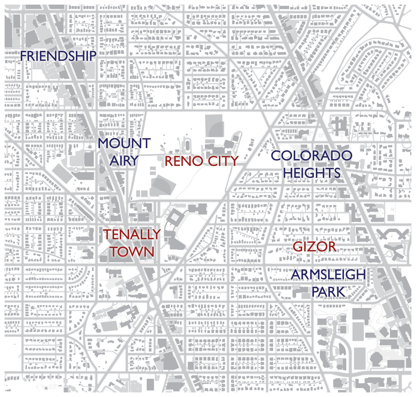
A few historical neighborhood names. Red text indicates a natural name while blue indicates a development.
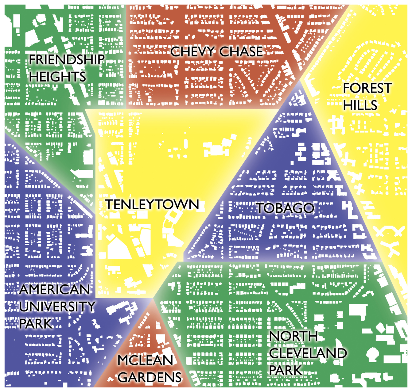
Now, the names of the neighborhoods today are not any better than the ones lost to time. Just for example, here's how Wikipedia divides the area, based on real estate convention:
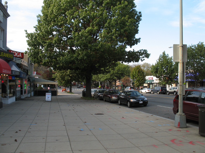
Here, neighborhood divisions pass right through the centers of activity, such as on Wisconsin Ave. By this map, the vast majority of what people regard as Tenleytown is not in Tenleytown, such as the Janney School, Cityline at Tenley, and the Tenley-Friendship Library hole. It is as though the places where most neighborhood activity occurs have no bearing on the official geography. With that in mind, I asked some friends where neighborhoods begin and end. Here's what I came up with:
In my opinion, this map reflects the general image of neighborhoods better, especially in the way it characterizes Tenleytown, but it's still somewhat imperfect. For example, the Comet Corner node at Connecticut and Nebraska is still stuck between Chevy Chase, Forest Hills, and Tobago. Or, take the Van Ness hub, which is technically split between Forest Hills and North Cleveland Park. And, good lord, parts of AU park are a mile from American's main campus.
Now, crumby names may not actually harm the businesses at these locations, but I have found it strangely hard to explain to outsiders how to get to Politics & Prose. It just does not exist on the mental maps of most inhabitants of the region. The lack of landmarks or a transportation node might be one reason it's unremarkable, but the fact that people have spontaneously named the area suggests that area is not so much lacking as the naming system is itself insufficient.
Although a line is drawn down the middle of Wisconsin Avenue, a person will not feel that the neighborhood changed when he or she crosses the street. Both sides of the street sit in the same space – and one perceives them as the same place. So, from an urbanist standpoint, it makes more sense to approach neighborhood names through the experience of space and human activity.
In the next post, I explore an alternative.
Comments
- Successful speed cameras require fair speed limits
- Amid scandal, don't lose sight of Gray's policy achievements
- VDOT ignores own data, pushes widening I-66
- Montgomery plans 160-mile, "gold standard" BRT system
- DC's divide need not be black and white
- Preservationists ask to shrink 3rd Church replacement
- Planners are the new public health officials


Trying to set hard limits on where nebulous neighborhoods begin and end is kind of a fruitless endeavor, because, as we see here, everyone has a different opinion. And there really isn't a point to drawing a straight line across a street to define these places, unless you're an elite trying to shut people out of your neighborhood, or a real estate agent trying to make a property seem like it is in a more elite neighborhood.
An interesting exercise we did in one of our college geography classes was to take a map of the United States (no state boundaries) and draw the regions of the US on it. There was no list of names to pick from. 30 people in the class - 30 different answers.
by MLD on Feb 25, 2010 12:40 pm
Maybe that's the one slightly positive thing suburbia has given us. Developments with limited access points and defined HOA allegiances. Too bad they may have unique names but they still all look alike.
by kidincredible on Feb 25, 2010 12:49 pm
by John on Feb 25, 2010 1:01 pm
Having moved to Chevy Chase from out of the region, I did try to define neighborhoods as a way to get my bearings. This is what I came up with, at least along Connecticut Ave:
- Cleveland Park ended at Tilden.
- Van Ness went from Tilden to Chesapeake/Davenport (solely based on the fact that a lot of people always got off at the Davenport bus stop)
- Unnamed Area from Chesapeake/Davenport to Nebraska
- Chevy Chase went from Nebraska to District Edge.
I know that doesn't solve anything, but I thought I would give an outsiders perspective. I have since moved to the Hill (which is another discussion because the Hill is way too large to be one neighborhood... often I say I live in Eastern Market).
by David Uhl on Feb 25, 2010 1:48 pm
by Matthias on Feb 25, 2010 1:59 pm
by sassymolassy on Feb 25, 2010 2:49 pm
we always called the neighborhood "menopause manor" - a moniker that came into existence at least twenty years ago, according to a colleague who grew up there.
by AJ on Feb 25, 2010 2:53 pm
Awesome.
by Reid on Feb 25, 2010 3:12 pm
by Neil Flanagan on Feb 25, 2010 3:16 pm
by Thayer-D on Feb 25, 2010 3:23 pm
by Bianchi on Feb 25, 2010 3:26 pm
by Tom Veil on Feb 25, 2010 3:29 pm
by Andrew on Feb 25, 2010 4:14 pm
As a few people have pointed out, the lines could be drawn in a number of places, but most people picked the big streets to be the borders.
by Neil Flanagan on Feb 25, 2010 4:15 pm
by SDee on Feb 25, 2010 4:27 pm
by neff on Feb 25, 2010 4:51 pm
by kenyonstreet on Feb 25, 2010 4:53 pm
How about renaming "Wakefield" [I've never heard of it in my lifetime living here] to "Reno City," which is the historical name for the area east of including Ft. Reno, home to D.C.'s first community of freed slaves.
by arm on Feb 25, 2010 5:12 pm
forest hills: bounded by conn ave on the west, tilden to the south, the park to the east, and 36th/broadbranch to the north.
by AJ on Feb 25, 2010 5:29 pm
by Neil Flanagan on Feb 25, 2010 8:03 pm
by Michael on Feb 25, 2010 8:51 pm
And that's all it ever shall be.
by MPC on Feb 25, 2010 9:02 pm
An odd, funny name for an urban neighborhood is generally unacceptable because, simply, most of the people who reside there won't like it. It's as basic as that. Oh, to be sure, a funky area in a city might acquire an interesting nickname, but to be labeled officially as such will not likely pass muster with residents and authorities alike. To often names get twisted about and become fodder for puns and double entendres. All the more so for "mirth"-ful names.
Why of all possible appellations did you select the name "Tobago"? Really now. In what way does the name Tobago apply to this area? Is there any historical connection, or any connection at all?
"Wakefield" is an pleasant, innocuous appellation. But, again, how does it apply to the area?
by Anonymous on Feb 25, 2010 9:41 pm
And what's wrong with double entendres? Madam's Organ is a treasure.
by Neil Flanagan on Feb 26, 2010 12:29 am
The same thing occurs elsewhere. people near Kalorama Triangle like to claim they're in Kalorama rather than Adams-Morgan. the historic district(s) that have or may develop in Adams Morgan are likely to revive Washington Heights and Lanier Heights as Place names, which sound a little classier than A-M. I've also noticed that people claim Logan Circle when people barely live in the Eastern end of Shaw. Then, there's the question of where Georgetown turns to Glover Park, along Wisconsin Avenue.
by Rich on Feb 26, 2010 12:53 am
I enjoyed the post and appreciate the effort, but it's not particularly useful to choose goofy neighborhood names hoping they'll stick.
by hnc on Feb 26, 2010 11:08 am
Meanwhile, thanks for the link. I had no idea Frank Winstead had a youtube account, but I hadn't moved back to DC during that bullroar.
by Neil Flanagan on Feb 26, 2010 11:31 am
by Andrew on Feb 26, 2010 11:58 am
One other issue with your map - I've never heard someone say 'North Cleveland Park' in my life. I think 'Van Ness' is a much more natural name for the area, and it's often used.
by hnc on Feb 26, 2010 1:29 pm
by tom a. on Feb 26, 2010 5:42 pm
by MattF on Feb 27, 2010 10:39 am
and rich: there isn't a question of where georgetown becomes glover park, because there is another neighborhood in between (burleith).
by IMGoph on Feb 28, 2010 11:51 pm
Add a Comment